
 PDF
Integrative GIS-Based Mapping of Active Mining Sites, Exclusion Zones, and Potential Mining Areas in Southwestern Nigeria
Article Sidebar
 https://doi.org/10.32487/nuce.v5i2.746
PDF downloads: 56
Main Article Content


Abstract
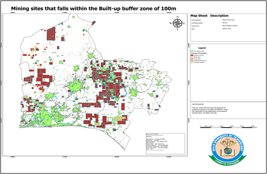
Nigeria's mining sector was once a major driver of national economic growth during the 1960s and 1970s, but its prominence declined sharply following the rise of the crude oil industry, leaving it with a marginal GDP share of just 0.17% between 2018 and 2022. Reports from the Development Agenda for Western Nigeria Commission highlight that the country's Southwestern states possess rich mineral reserves such as gold, tin, zircon, rutile, feldspar, and quartz giving the region strong potential to emerge as a global mining hub. Realizing this potential, however, has been constrained by illegal mining operations, overlapping land-use claims, and a lack of reliable spatial data, all of which have undermined effective resource planning and revenue collection. In response, this study carried out a spatial mapping exercise to delineate zones suitable for mineral exploration and extraction, drawing on land use and land cover data to distinguish built-up settlements, licensed mining concessions, and legally restricted zones as defined under the Nigerian Minerals and Mining Act 2007. Findings show that of the region's total 78,771 km² landmass, 13,755.7 km² is already under licence, while 49,765.2 km² representing 63.2% of the area remains available for future mineral leasing. The analysis further identified 1,434 active mining sites, over half of which (759, or 52.9%) overlap with land designated for residential expansion, pointing to considerable spatial conflict. The study concludes that GIS-driven spatial analysis offers a robust tool for guiding licence allocation, land-use planning, and environmentally responsible mining development across Nigeria.
Downloads Statistics
Article Details

 This work is licensed under a Creative Commons Attribution-NonCommercial 4.0 International License. Any further distribution of this work must maintain attribution to the author(s) and the title of the work, journal citation and DOI.
References
Azubuike, S. I., Nakanwagi, S., & Pinto, J. (2023). Mining resource corridor development in Nigeria: Critical considerations and actions for a diversified and sustainable economic future. Mineral Economics, 36(1), 59-75. https://doi.org/10.1007/s13563-022-00307-5
Bonham-Carter, G. F. (1994). Geographic information systems for geoscientists: Modelling with GIS. Pergamon.
Carranza, E. J. M. (2009). Geochemical anomaly and mineral prospectivity mapping in GIS (Handbook of Exploration and Environmental Geochemistry, Vol. 11). Elsevier.
Carranza, E. J. M., & Laborte, A. G. (2015). Data-driven predictive mapping of gold prospectivity, Baguio District, Philippines: Application of random forests algorithm. Ore Geology Reviews, 71, 777-787. https://doi.org/10.1016/j.oregeorev.2014.08.010
Congalton, R. G., & Green, K. (2019). Assessing the accuracy of remotely sensed data: Principles and practices (3rd ed.). CRC Press.
Economic Commission for Africa. (2017). African Minerals Governance Framework. United Nations Economic Commission for Africa.
Edwards, D. P., Sloan, S., Weng, L. F., Dirks, P., Sayer, J., & Laurance, W. F. (2014). Mining and the African environment. Conservation Letters, 7(3), 302-311. https://doi.org/10.1111/conl.12076
Esri. (2024). ArcGIS Pro documentation. https://pro.arcgis.com
European Space Agency. (2015). Sentinel-2 user guide. https://sentinels.copernicus.eu/web/sentinel/user-guides/document-library
Federal Republic of Nigeria. (1999). Constitution of the Federal Republic of Nigeria, 1999 (as amended). Federal Government Printer.
Federal Republic of Nigeria. (2007). Nigerian Minerals and Mining Act, No. 20 of 2007. Federal Government Printer.
Hilson, G., & Maconachie, R. (2020). For the environment: An assessment of recent military intervention in informal gold mining communities in Ghana. Land Use Policy, 96, 104706. https://doi.org/10.1016/j.landusepol.2020.104706
Lakhlifa, B., Amraoui, T., Tobi, A., Ibouh, H., Zaid, K., Elamari, K., & Hibti, M. (2022). Geological mapping and mining prospecting in the Aouli Inlier (Eastern Meseta, Morocco) based on remote sensing and geographic information systems (GIS). China Geology, 5. https://doi.org/10.31035/cg2022035
Longley, P. A., Goodchild, M. F., Maguire, D. J., & Rhind, D. W. (2015). Geographic information science and systems. Wiley.
Maus, V., Giljum, S., da Silva, D. M., Gutschlhofer, J., da Rosa, R. P., Luckeneder, S., Gass, S. L. B., & McCallum, I. (2022). An update on global mining land use. Scientific Data, 9, 433. https://doi.org/10.1038/s41597-022-01547-4
Maus, V., Giljum, S., Gutschlhofer, J., da Silva, D. M., Probst, M., Gass, S. L. B., Luckeneder, S., Lieber, M., & McCallum, I. (2020). A global-scale data set of mining areas. Scientific Data, 7(1), 289. https://doi.org/10.1038/s41597-020-00624-w
McMahon, G., & Moreira, S. (2014). The contribution of the mining sector to socioeconomic and human development. World Bank. https://openknowledge.worldbank.org/handle/10986/18660
Moran, C. J., Lodhia, S., Kunz, N. C., & Huisingh, D. (2014). Sustainability in mining, minerals and energy: New processes, pathways and human interactions for a cautiously optimistic future. Journal of Cleaner Production, 84, 1-15. https://doi.org/10.1016/j.jclepro.2014.09.016
Ngom, N. M., Baratoux, D., Bolay, M., & Dessertine, A. (2023). Artisanal exploitation of mineral resources: Remote sensing observations of environmental consequences, social and ethical aspects. Surveys in Geophysics, 44(1), 225-247. https://doi.org/10.1007/s10712-022-09740-1
Olujobi, O. J., & Irumekhai, O. S. (2024). Strategies and regulatory measures for combatting illicit mining operations in Nigeria: A comprehensive legal perspective. Resources Policy, 88, 104459. https://doi.org/10.1016/j.resourpol.2023.104459
O'Sullivan, D., & Unwin, D. J. (2010). Geographic information analysis. Wiley. https://doi.org/10.1002/9780470549094
Porwal, A., Carranza, E. J. M., & Hale, M. (2003). Knowledge-driven and data-driven fuzzy models for predictive mineral potential mapping. Natural Resources Research, 12(1), 1-25. https://doi.org/10.1023/A:1022693220894
Richards, J. A. (2022). Remote sensing digital image analysis: An introduction (6th ed.). Springer. https://doi.org/10.1007/978-3-030-82327-6
Sánchez, F., & Hartlieb, P. (2020). Innovation in the mining industry: Technological trends and a case study of the challenges of disruptive innovation. Mining, Metallurgy & Exploration, 37(5), 1385-1399. https://doi.org/10.1007/s42461-020-00262-1
Shirmard, H., Farahbakhsh, E., Müller, R. D., & Chandra, R. (2022). A review of machine learning in processing remote sensing data for mineral exploration. Remote Sensing of Environment, 268, 112750. https://doi.org/10.1016/j.rse.2021.112750
Sonter, L. J., Ali, S. H., & Watson, J. E. M. (2018). Mining and biodiversity: Key issues and research needs in conservation science. Proceedings of the Royal Society B: Biological Sciences, 285, 20181926. https://doi.org/10.1098/rspb.2018.1926
Tagwai, M. G., Jimoh, O. A., Shehu, S. A., & Zabidi, H. (2023). Application of GIS and remote sensing in mineral exploration: Current and future perspectives. World Journal of Engineering, 21, 487-502. https://doi.org/10.1108/WJE-09-2022-0395
Tomlin, C. D. (1990). Geographic information systems and cartographic modeling. Prentice Hall.
Werner, T. T., Bebbington, A. J., & Gregory, G. (2019). Assessing impacts of mining: Recent contributions from GIS and remote sensing. The Extractive Industries and Society.
Yousefi, M., Carranza, E. J. M., Kreuzer, O. P., Nykänen, V., Hronsky, J. M. A., & Mihalasky, M. J. (2021). Data analysis methods for prospectivity modelling as applied to mineral exploration targeting: State-of-the-art and outlook. Journal of Geochemical Exploration, 229, 106839. https://doi.org/10.1016/j.gexplo.2021.106839