
 PDF
PDF
Accuracy Assessment of Smartphone-Based 2D Positioning: Checking ItsSuitability for Non-Survey Geospatial Applications
Article Sidebar
 https://doi.org/10.32487/nuce.v4i1.716
PDF downloads: 65
Main Article Content

Abstract
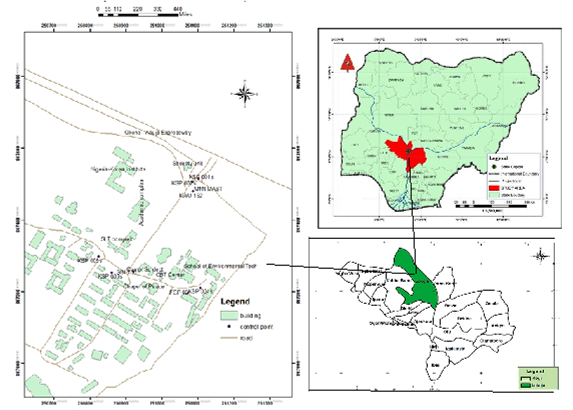
This study explores the potential of smartphone-based 3rd order 2D surveying as a cost-effective alternative for mapping and geospatial data acquisition. Traditional surveying methods rely on expensive equipment, but smartphones offer a promising solution, leveraging their widespread availability and accessibility. The study evaluates the accuracy and reliability of smartphone-based 2D surveying techniques, focusing on environmental factors that impact accuracy. The research uses a Vivo Y04 smartphone with SW Maps and Geo++ RINEX Logger apps to collect data at seven control points in Lokoja, Nigeria. Results show that environmental factors like buildings, trees, and telecommunication masts significantly impact accuracy, with deviations ranging from 0.337m to 8.036m.Control points in open fields with good satellite geometry achieved deviations of less than 100cm, while those near obstacles showed larger discrepancies. The SW Maps app demonstrated more reliable results compared to Geo++ RINEX. A hybrid approach combining satellite surveying with traditional methods can help achieve accurate results. The study highlights the potential of smartphone-based surveying for small-scale projects, developing countries, or applications with limited budgets. However, careful planning and selection of survey locations are crucial to minimize errors. The findings have implications for urban planning, environmental monitoring, and infrastructure development, and suggest that smartphone-based 3rd order 2D positioning can be a viable alternative for geospatial data acquisition. By understanding the limitations and capabilities of smartphone-based surveying, professionals can leverage this technology to achieve accurate and reliable geospatial data. Further research is needed to optimize location-based services in urban settings and to investigate the impact of different smartphone models and surveying techniques on accuracy
Downloads Statistics
Article Details
 This work is licensed under a Creative Commons Attribution-NonCommercial 4.0 International License. Any further distribution of this work must maintain attribution to the author(s) and the title of the work, journal citation and DOI.
References
Ashraf, I., Park, Y., Zikria, Y.B. and Din, S. (2023). Sensors 2023, 23(8), 3811. https://doi.org/10.3390/s23083811
Boarotto, F., Monti, R. and Palmurella, F. (2020). Third order open mapping theorems and applications to the end point map. https://doi.org/10.1088/1361-6544/ab8bad
Bori, M.M., Hussein, Z.E., Jasim, Z.N. and Alsadik, B. (2026). Geometric Reliability of AI-Enhanced Super-Resolution in Video-Based 3D Spatial Modeling. ISPRS International Journal of Geoinformation (IJGI). https://doi.org/10.3390/ijgi15030125
David H. (2026). GPS Uncertainty. David Harbor W & L Geology Department. Accessed from https://www.harbor.academic.wlu.edu
Guma, E.P., Agada, D.U., Johnson, N.G., Omopariola, D.E., Aremu, R., Shaba, T. and Olonilebi, P. (2023). Detecting errors in GNSS-Precise Point Positioning controls using Total Station Technique. Coou African Journal of Environmental Research, Vol 4, No. 1, 2023, page 83 – 93.
Hu, J., Ding, Y. and Bisnath, S. (2023). A Comprehensive Analysis of Smartphone GNSS Range Errors in Realistic Environments. Sensors 2023, 23(3), 1631. Accessed from https://www.doi.org/10.3390/s23031631
Huang, J., Guo, Y., Li, X., Zhang, N., Jiang, J., and Wang, G. (2022). Evaluation of Positioning Accuracy of Smartphones under different Canopy Openness. Accessed from https://www.doi.ord/10.3390/f13101591
Hyunwoo P. (2025). A Study on Application of Real-Time Precise Positioning Systems on Smartphone. Accessed from https://www.s-space.snu.ac.kr/handle/10371/220295.
Ka, H., Marco, L. and Susan B. (2023). The smart-home study: A feasibility study to pilot the use of smartphone technology to identify environmental falls risk factors in the home. Hong Kong Journal of Occupational Therapy 2023, Vol. 36(1) 3–12. Accessed from https://www.4journals.sagepub.com/home/hjo
Kumar, S. S., Chowdhury, M. M. and Islam, M. R. (2019). Smartphone-based photogrammetry for 3D modeling of urban environment. Journal of Applied Geodesy, vol. 13, no. 2, pp. 123-134, 2019.
Maciej, M. N., Katarzyna D., Łukasz, L. and Julian, C. (2020). Mobile GIS applications for environmental field surveys: A state of the art. Global Ecology and Conservation, Volume 23, September 2020, e01089. Accessed from https://www.doi.org/10.1016/j.gecco.2020.e01089.
Merry K, and Bettinger P (2019). Smartphone GPS accuracy study in an urban environment. PLoS ONE 14(7): e0219890. https://doi.org/10.1371/journal.pone.0219890
Qi L., Chengfa G., Zihan, P., Ruicheng, Z. and Rui S. (2021). Smartphone Positioning and Accuracy Analysis Based on Real-Time Regional Ionospheric Correction Model. Sensors 2021, 21(11), 3879; https://doi.org/10.3390/s21113879
Raufu, I.O., Adewole, B.E., Tata, H. and Olaoye, C.A. (2025). Accuracy and reliability of smarthphones GNSS applications: A comparative study with handheld GPS Device for position determination. World scientific news 202 (2025), 66-77. https://www.worldscientificnews.com
Saad, F. H, Jasim, O. Z. and Albayati, M. M. A. (2023). Literature review of mobile spatial data collection and related to reality as a basis for the geomatics applications. IOP Conference Series: Earth and Environmental Science. Accessed from https://www.doi.ord/10.1088/17551315/1129/1/012009
Sarker, R.A., Hassanuzzaman, M., Biswas, P., Dadon, S.H., Imam, T. and Rahman, T. (2021). Sensors 2021, 21(21), 6969. https://doi.org/10.3390/s21216969
Uradziński, A. and M. Bakuła (2020). Assessment of Static Positioning Accuracy Using Low-Cost Smartphone GPS Devices for Geodetic Survey Points’ Determination and Monitoring. Appl. Sci. 2020, 10(15), 5308; https://doi.org/10.3390/app10155308