
 PDF
PDF
Road Surface Damage Analysis Using GIS Based Bina Marga Method
Article Sidebar
 https://doi.org/10.32487/nuce.v1i2.391
PDF downloads: 553
Main Article Content

Abstract
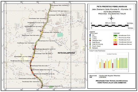
The function of Primary arterial street is to serve as road users to connect to the national activity center and for regional activity, which is long-distance travel. On that road, there are so many roads damaged, damaged due to heavy vehicle loads and some high frequencies. The study aims to identify the type of damage and to help in how the maintenance management of this street through system will be managed and systematically stored in the form of databases. The research used Bina Marga methods, assessments of road conditions refer to the Organizing of Urban Road Maintenance Programs issued by the Directorate General of Bina Marga. The survey was divided into 20 segments per 100 meters, the data were obtained from field surveys, with damage data and field photos, and then input data of the street table that use the file formats in ArcGIS software, and later data can be further analyzed. Research shows that the dominant damage happens in grains and patching. Research results on the road of Soekarno-Hatta KM 8-10 have a pretty low rate of damage, shown by the maintenance priorities listed in a regular maintenance program, which means maintenance or repair simply top layer without repairing road structures
Downloads Statistics
Article Details
 This work is licensed under a Creative Commons Attribution-NonCommercial 4.0 International License. Any further distribution of this work must maintain attribution to the author(s) and the title of the work, journal citation and DOI.
References
Jayal, E. A. (2016). Buku Sistem Informasi (Issue December).
Jannah, R. L., Yermadona, H., & Dewi, S. (2022). Analisis Kerusakan Perkerasan Jalan Dengan Metoda Bina Marga Dan Pavement Condition Index (PCI)(Studi kasus: Jl. Lintas Sumatera Km 203-213). Ensiklopedia Research and Community Service Review, 1(2), 114-122.
Ibrahim A., (2021) “Analisis Kerusakan Jalan Ruhui Rahayu I – Jalan Sepinggan Baru Balikpapan Dengan Menggunakan Metode Pavement Condition Index ”, Jutateks, Vol. 5, No. 1, Pp. 117-123.
Ibrohim, M. (2019). Sistem Informasi Geografis Tingkat Kerusakan Ruas Jalan Berbasis Web. JSiI (Jurnal Sistem Informasi), 6(1), 20-31.
Kurniawan, M. K., Sulistyo, T., & Giarto, R. B. (2002). Road Defects Analysis of Mulawarman Street STA 00+ 000–03+ 300 Using Pavement Condition Index (PCI) Method. Nusantara, 1(1), 1-8. https://doi.org/10.32487/nuce.v1i1.382