Pengukuran Topografi Untuk Menghitung Volume Cut And Fill Pada Perencanaan Pembangunan Perumahan Di Km. 10 Kota Balikpapan
Abstract
The plan to move Indonesian State Capital from Jakarta to East Kalimantan has an impact on increasing population growth and community demand to own land and build residential buildings. 2 hectare area (20,000 m2) located at Km. 10 Balikpapan City is planned as a housing development. The area has varied land contours so it requires topographical measurements as a need for land excavation and stockpiling.
This research conducted study literature such as data collection, data processing, conclusions and suggestions. The research uses topographic exchange data carried out by the researcher and the team. The volume is calculated using the average cross-sectional method and the square pyramid method.
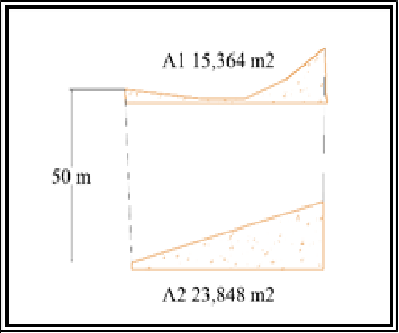
The calculation result, volume using cross-sectional method, cut = 425 m³ and fill = 2850 m³. While the volume using pyramid method, cut = 312.01 m³ and fill = 8689 m³. From the average calculation results of the two methods, it is obtained that the amount of land reserve for ordinary soil types is 368.505 BCM with a stockpile volume of 5769.565 m3. They experience volume changes in loose conditions 460.631 LCM and solid conditions 331.654 CCM.
Downloads Statistics
References
Agor, R. 1982. "A Text Book of Surveying & Levelling". Delhi,India: Khana Publisher
Asiacon. 2015. "Cut and Fill: Definisi, Tujuan dan Tahap Perencanaan". Retrieved from Asiacon.
Golden Software, 2002 “Surfer: User Guide Contouring and 3D Surface Mapping For Scientists and Engineers”. Golden Software, Inc. Press Colorado.
Hasan, Ahmad Fatihul. 2018. “Perhitungan Volume Cut and Fill Pada Perencanaan Jalan Tol Km 28 Balikpapan – Samarinda”. Tugas Akhir. Balikpapan: Politeknik Negeri Balikpapan.
Indra, S. M. 1997. “Pengukuran dan Pemetaan Pekejaan Konstruksi”. Jakarta: Pustaka Sinar Harapan
Iskandar, M. 2008. “Teknik Survey dan Pemetaan Jilid 3”. Jakarta: Direktorat Pembinaan Sekolah Menengah Kejuruan
Marlina, Endy. 2005. Perencanaan dan Pengembangan Perumahan. Andi Offset. Yogyakarta.
Mohamad, Ali. 1982. “Penelitiuan Kependidikan”. Bandung: Angkasa
Iqbal, Muhammad. 2019. “Pembuatan Siteplan Dan Perhitungan Volume Cut And Fill Pada Perncanaan Workshop Pt. United Hydraulic Technology Kota Balikpapan”. Tugas Akhir. Balikpapan: Politeknik Negeri Balikpapan
Purworahardjo, U. 1989. “Ilmu Ukur Tanah Seri C. Fakultas Teknik Sipil dan Perencanaan”. Bandung: Institut Teknologi Bandung
Rahayu, L.P. 2015. “Studi Perbandingan Perhitungan Volume Menggunakan Data Total Station Dengan Dan Tanpa Prisma”. Surabaya
Riadi, Ocky Pradikha. 2015. “Land Clearing Pada Proses Penambangan Bahan Tambang.
Sinaga, I., 1997. “Pengukuran dan Pekerjaan Pemetaan Konstruksi”. Jakarta: Pustaka Sinar Harapan
Sulistyo, Totok. "Application of GIS to improve accuracy and save time in Cut and Fill Calculation: A case study of Bunga Club Project PT. Tanjung Pura Resorts Balikpapan." JIP (Jurnal Ilmiah Politeknik) 1.1 (2007).
Yuwono. 2004. “Modul Pendidikan dan Pelatihan Teknis Pengukuran dan Pemetaan Kota”. Jurusan Teknik Geodesi FTSP. Surabaya: Institut Teknologi Sepuluh Nopember